


Different geospatial processes require different levels of autonomy. The future operating model is built on confidence thresholds, business risk and human governance.
Geospatial operations are entering a new maturity curve. For years, map production and maintenance depended on people reviewing imagery, validating topology, correcting geometry, and approving every meaningful change. “Human in the loop” (HITL) helped enterprises build trust in AI because people remained close to every output. But as map change signals multiply across satellite imagery, aerial imagery, street-level imagery, municipal feeds, and user feedback, the old model becomes difficult to scale.
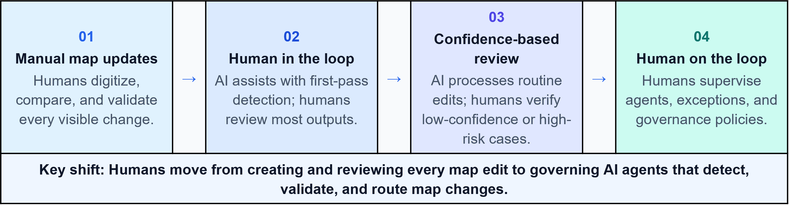
The next step is not to remove people from the process. It is to move them to the right level of the process. In a “human on the loop” (HOTL) model, AI agents handle routine detection, validation, and routing, while human experts supervise exceptions, define policies, audit outcomes, and continuously improve the system. This is the rise of the Map Intelligence Supervisor.
Figure 1. The operating shift from task-level validation to exception-based supervision.
Why HITL was necessary, but no longer enough
Human in the loop was the right starting point for enterprise AI. It helped organizations combine machine speed with human judgment. AI could detect a possible road change, identify a lane marking, classify an asset, or interpret an input signal, while humans verified the output and protected quality.
However, the limitation is scale. If every map edit, road attribute update, and point-of-interest change requires manual review, the operation continues to grow in proportion to human capacity. This makes the model expensive and slow as geospatial data becomes continuous, dynamic, and sourced from multiple inputs.
The future is not a binary choice between manual work and full automation. The better question is which classes of geospatial work warrant full autonomy, supervised autonomy, or expert intervention. This is where Human on the Loop becomes a practical operating model rather than a theoretical concept.
How increasing AI dependability moves HITL to HOTL
The transition from Human in the loop to Human on the loop is ultimately driven by improvements in AI dependability and accuracy. In early deployments, human reviewers validated a large percentage of outputs because model confidence was still evolving. As AI agents improve through continuous learning, feedback loops, and governance controls, confidence increases and the volume of exceptions requiring human validation declines.
Beyond a defined trust threshold, reviewing every transaction becomes unnecessary. At this point, the operating model naturally evolves from HITL to HOTL: humans move from validating individual outputs to supervising exceptions, policies, and system performance. The transition should therefore be based not on automation ambition alone, but on measurable improvements in AI accuracy, consistency, and dependability, with business risk and governance determining the threshold for each geospatial process.
Why geospatial map maintenance is the right example
Geospatial map maintenance is one of the clearest use cases to explain this shift because maps are never truly finished. Roads change. Lanes are added. Intersections are redesigned. Speed limits are updated. Points of interest open, close, or move. Construction zones create temporary diversions. New imagery and operational feeds keep revealing changes that need to be interpreted and reflected in digital maps.
In a traditional model, humans spend a large amount of time reviewing imagery, comparing map layers, validating geometry, and deciding whether a map update is required. This is valuable work, but much of it is repetitive. Real expertise lies not in reviewing every routine change, but in understanding which changes are risky, ambiguous, safety-sensitive, or commercially important.
That is why geospatial operations are well positioned for Human on the Loop. AI agents can detect and process routine map changes at scale. Human experts can focus on the smaller set of changes for which judgment, local context, safety knowledge, and policy interpretation matter most.
From manual map edits to AI-supervised map operations
In the human-in-the-loop version of map maintenance, an AI model may identify a possible new road, changed lane marking, or updated point of interest (PoI). A human analyst reviews the findings, checks the imagery, compares them with existing map data, corrects errors, and approves the update. The process improves productivity, but the human remains involved in most units of work.
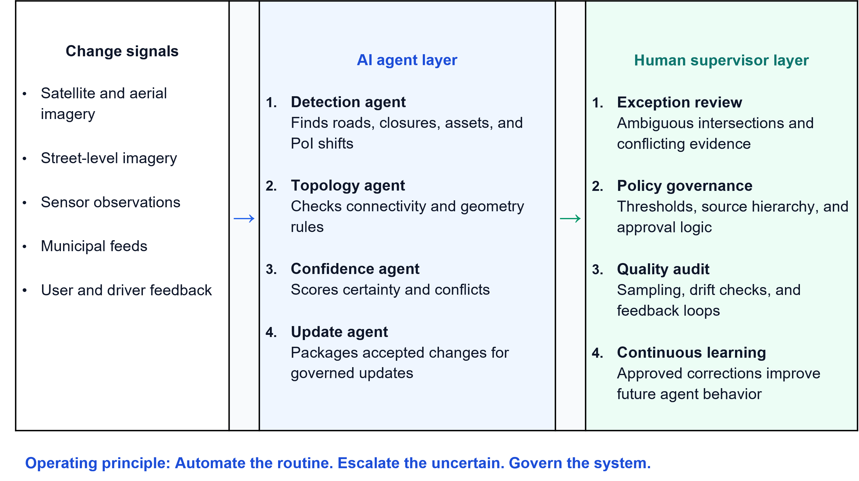
In the human-on-the-loop version, the system behaves differently. A detection agent identifies potential changes from multiple inputs. A topology agent checks whether the change fits the road network and map rules. A confidence agent scores certainty and identifies conflicts between sources. A workflow agent promotes high-confidence updates and routes uncertain cases to human experts.
The human expert no longer reviews everything. They only review what the system cannot confidently resolve. This is the heart of the shift. People move from checking the quality of every transaction to supervising an intelligent map maintenance ecosystem.
Figure 2. Human-on-the-loop reference model for geospatial map maintenance.
What should be automated and what should be supervised?
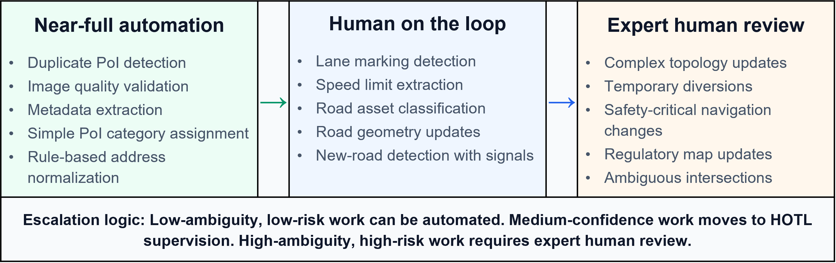
This is the most important implementation question. Not all geospatial processes carry the same level of risk. Some activities are repetitive, rule-based, and evidence-driven. These are suitable for near-full automation. Other activities involve ambiguity, conflicting sources, or downstream safety impacts. These should remain under human-on-the-loop supervision or expert review.
The operating model should therefore be driven by confidence thresholds and business risk. High-confidence, low-ambiguity processes can move toward autonomy. Medium-confidence processes should be supervised through exception queues and audit sampling. Low-confidence or high-risk processes should be escalated to expert decision-makers.
This makes HOTL practical. It avoids both extremes: over-reviewing routine tasks and over-automating sensitive decisions. The result is a balanced model in which machines handle volume and humans apply judgment.
Figure 3. Confidence-driven automation model for geospatial processes
The confidence-driven escalation model
A mature HOTL environment should automatically route work based on confidence thresholds. High-confidence activities can be executed autonomously with periodic audits. Medium-confidence activities should be reviewed through exception management and sampling. Low-confidence activities should be escalated to experts who make the final decision.
This confidence-driven design changes productivity economics. The system does not ask humans to review every map update. It asks humans to review the updates that need to be confirmed. That distinction is critical because it allows geospatial operations to scale without compromising trust, safety, or governance.
The goal is not to remove human expertise. It is to apply human expertise where it creates the greatest value. Human attention becomes a scarce asset that must be protected to mitigate ambiguity, handle exceptions, and bring continuous improvement.
The map intelligence supervisor operating model
The role of the future is not simply a map editor. It is that of a “map intelligence supervisor.” This role acts as an operational control tower for geospatial AI. It manages confidence thresholds, reviews exception queues, audits quality, monitors model drift, updates policies, and tunes AI agent behavior.
This person will also be responsible for onboarding new change patterns. For example, when a new road design, signage pattern, or temporary construction format appears frequently, the supervisor helps convert that exception into a learnable pattern. Over time, this reduces recurring manual review and improves the autonomy of the system.
Success is no longer measured by how many edits people perform. It is measured by how effectively humans govern millions of AI-generated decisions while intervening only where judgment, accountability, and domain expertise are required.
Credential-led observations from enterprise AI data operations
Across large-scale AI data and geospatial workflows, one pattern is becoming visible. Organizations first use AI to reduce manual effort through preprocessing, pre-labeling, active learning, and quality checks. At this stage, HITL remains essential because human experts review a large percentage of outputs and help the system learn.
As the system matures, the work begins to separate into three categories: near-full automation, supervised autonomy, and expert human review. This segmentation is what makes Human on the loop practical. It prevents blind automation while reducing unnecessary human effort on routine work.
For geospatial map maintenance, this means the enterprise can move from manual update throughput to intelligence-driven map operations. The differentiator is not only the number of analysts available. It is the maturity of the agents, the quality of the exception engine, the strength of the governance model, and the ability to continuously improve the system.
What organizations must build before moving to HOTL
Human on the loop should not be treated as a shortcut. It requires strong foundations. Organizations need clear confidence thresholds, reliable audit sampling, well-defined escalation rules, transparent quality dashboards, and domain-specific governance policies. They also need feedback loops to ensure that human corrections are not lost but are used to improve future AI behavior.
The transition should be gradual. A sensible path is to start with AI-assisted detection, and then introduce confidence-driven review, automate low-risk routine changes, and finally create a supervisory control layer in which humans monitor system performance and exceptions. This reduces risk while allowing the operation to scale.
The organizations that succeed will be the ones that treat HOTL not as a tool deployment, but as an operating model transformation.
The strategic takeaway
Human in the loop was designed for the era when AI needed close human correction. Human on the loop is designed for the era when AI systems can execute routine decisions but still need human supervision, governance, and accountability.
Geospatial map maintenance shows this evolution clearly. Maps will increasingly be updated through intelligent systems that detect change, assess confidence, check topology, and route exceptions. Human experts will not disappear from the process. Rather, they will rise above the process.
The future of geospatial AI is not about deciding whether AI does the work or people. It is about deciding which work warrants full autonomy, which work needs supervised autonomy, and which work requires expert intervention.
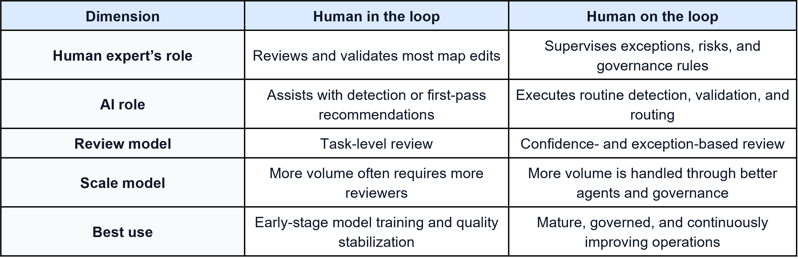
Table 1. Simple comparison of HITL and HOTL in map maintenance
Human in the loop made AI trustworthy. Human on the loop will make geospatial operations scalable, governed and enterprise-ready.